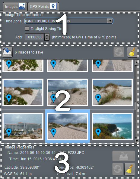
 The images tab consists of three parts:
- Adjustment of the time of the images relative to that of GPS tracks.
- Images List.
- Properties of the selected image.
Commands
Parts 2) and 3) have buttons for managing location metadata in images.
The buttons in zone 2) act on all the images.
The buttons in area 3) only affect the selected image.
 Saves geolocation data in image files.
Depending on the configuration, the original file is saved.
 Resets the geolocation data.
If GPS traces are loaded, the program uses them to try to locate the image.
If no track is loaded or there is no match, the data are cleared.
 Restores geolocation data
After a data reset, if the result is not satisfactory, restore the data from the image files.
 Setting the time offset
The dates in the GPS files are all in Greenwich Mean Time (GMT), while the dates for the images are in local time.
It is thus sufficient to specify the time zone of the setting of the camera, and possibly if the daylight saving was used to determine the time offset. If the time of the device was not exactly set, it is possible to adjust this offset.
The position of the images adjusts automatically which can help determine the time gap when the position of certain images is known!
 Images List
Thumbnails of images are shown in this list. Those that have GPS data are marked:
Indicates an image whose data has not been modified
Indicates an image (not yet saved) whose data has been modified.
Indicates an image (not yet saved) whose data has been deleted
It is possible to visualize an image by double clicking on its thumbnail.
 Properties
The properties of the selected image appear in this block. We find there:
- The file name
- The time of the image (it is the EXIF data “DateTimeOriginal” if present or the date of the file otherwise)
- The latitude and longitude of the image
- Elevation (WGS-84) and altitude (Sea level)
Yellow values indicates modified (not yet saved) data for the image.
Recent Comments