The upper bar of PicaGeoTag is used to load the images to be processed as well as the GPS tracks to be used.
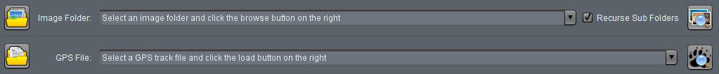
There are two groups:
- The first line is for loading of images and tracks from directories.
- The second line is used to load GPS files that would not be in the same directory as the images.
The two groups have the same arrangement:
- On the left the buttons allow to search and open the directories or files. Loading is started automatically when the dialog is closed.
- In the center the combo box allows to choose from the last four slots used.
- On the right the buttons start the (re)loading of images or GPS files. For directories, you can specify if you want to walk down the subtrees!
Loading directories
For ease of use, it is advised to group images and GPS files in the same directories. In this case, images and tracks are loaded at the same time automatically. The images are immediately positionned. You may have to adjust the time lag and save!
Warning: Loading images or tracks from directories clear all already loaded images or tracks.
Loading GPS files
GPS files can be added one by one. PicaGeoTag recognizes gpx or kml/kmz file type.
Note: Loading a GPS file retains the images and GPS files already loaded.
Recent Comments