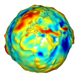
 By construction, GPS devices records the altitudes relatively to the reference ellipsoid WGS-84. But, since the earth is not homogeneous, there are differences in gravity from one place to another. As a result, the ellipsoid does not match with the sea level. The deviations can reach ±80m! In fact the earth is all battered.
Different models more or less accurate or usefull can translate from the ellipsoid to the sea level. PicaGeoTag uses a model of theNational Geospatial-Intelligence Agency to convert altitudes.
There are essentially two GPS file formats:
- The type files gpx Which explicitly specifies that the altitudes are relative to the ellipsoid.
- The type files kml and kmz used by Google Earth have several references of which the level of the sea, but not WGS-84!
Unfortunately not everyone follows the same rules:
- Some GPS units give the altitudes relative to sea level without knowing which correction model is used.
- Some GPS applications generate gpx files that use sea level as a reference.
- Conversely, some GPS applications generate kml/kmz files with altitudes relative to the ellipsoid.
In short it is the jungle! So if the altitudes are important to you (do not forget that the GPS has an accuracy of ± 5m), check the data obtained by your devices when you are in places where altitude is known.
For recording in EXIF images, the specification is completely blurred on the reference to be used. If your device has a GPS, check the reference used with the manufacturer if available. PicaGeoTag gives you the choice. The tag GPSMapDatum is used to records the reference used.
You can setup PicaGeoTag for all these situations.
Recent Comments